Category: FIRES:The New Normal
INSURANCE DENIED
FIRE MAKERS Set to Burn Us Up Santa Ana Winds BLOW FIRES to Burn ALL the Way to the OCEAN California Fire Season Starts! 9-16-19
|
FIRE MAKERS Set to Burn Us Up
Santa Ana Winds BLOW
FIRES to Burn ALL the Way to the OCEAN
California Fire Season Starts!
9-16-19
NOTE: FIRES are PLANNED “EVERYWHERE” Not Only in California
To Verify You Need to Look at the Climate Action Plan that has ALREADY been adopted in your town.
For More Information go to StopTheCrime.net and watch the
|
|
|
https://www.insurancejournal.com/news/west/2019/09/16/540074.htm
Santa Ana Winds Return to California Bringing Wildfire DangerThe Santa Ana winds have returned to California, a signal to the state’s residents that the wildfire season has begun in earnest.
The winds are created by high pressure over Nevada’s Great Basin as cool weather starts to arrive in the Fall. Low pressure systems in warmer California pull them along, and as they flow through the Sierra Nevadas and other ranges, twisting their way through narrow passes and canyons, they heat up, lose moisture and gain speed.
Let’s be clear – this article omits the facts of weather weapons. We are heavily sprayed overhead with fresh accelerants aka geoengineering, aka chemtrails just prior to fires being intentionally set.
The article continues: Once they hit California, their low humidity and high heat can quickly turn the bushy chaparral into an explosive fuel source. It’s part of the reason that California accounted for 92% of all insured wildfire losses in the U.S. from 2008 to 2018, according to insurer Munich Re. Colorado was second with 3%.
Manipulated weather to induce high wind speeds:
“The high winds cause the fires to spread incredibly rapidly,” according to Mark Bove, a natural catastrophe solutions manager at Munich Re. In some cases, he said, they have burned at the equivalent of “one football field per minute,” driven by the wind.
They also “cause more severe types of fire behavior,” Bove said, spurring “fire tornadoes or whirls” where the blazes move speedily from the ground to the tree tops.
In 2018, this behavior helped feed 6,284 fires that destroyed 876,147 acres in the state, while the so-called Camp Fire alone killed 86 people, making it the deadliest wildfire in state history. In response, California has set aside $1 billion for fire-prevention, and set up a $21 billion insurance fund to pay for future blazes sparked by utility company equipment.
Long known as Santa Anna winds in Southern California, similar winds are called “diablos” in northern California. Whatever the name, the winds have haven’t been a good combination with California’s local utilities.
Utilities run by Rothschild LLC and associates.
A series of wind-driven fires sparked by PG&E Corp. equipment forced the utility to seek bankruptcy protection in January. The company said it faced liabilities of $30 billion or more from claims tied to the fires that destroyed tens of thousands of structures and killed more than 100 people.
So far this year, wildfires haven’t done the level of damage seen in previous years. Through Sept. 8, 3,993 fires have burned about 36,683 in the state, substantially below the 271,740 five-year average, according to the California Department of Forestry & Fire Protection.
But much is at stake: Across California, 240,580 homes remain at extreme risk from fires, according to a new study from CoreLogic, a property data company in Irvine, California.
“During the Santa Anas, the hottest temperatures can be right at the ocean,” said Eric Boldt, warning coordination meteorologist for the National Weather Service in Los Angeles. “That is why these fires can burn all the way to the ocean.”
Remember to watch the YouTube video “Coastlines Under Attack”.
|
FIRES and Utilities Using Satellite Technology “in time” for 2019 Fire Season and Mind-warfare Combined
FIRES and Utilities
Using Satellite Technology “in time” for 2019 Fire Season
and
Mind-warfare Combined
Yes, IN TIME indeed, IN TIME to start fires by satellite with this absurd cover story.
How much longer will people believe in this New NORMAL OF CLIMATE CHANGE
vs
the FACTS that Climate Change is Weather Weapons?
INSIDER COMMENT
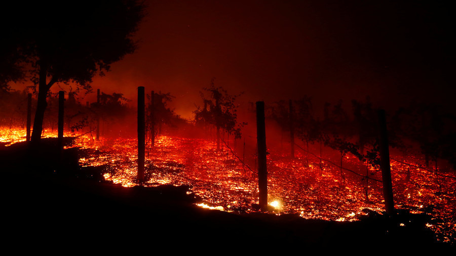
FIRE a BIG BUSINESS at HIGH COST Firefighters’ blood, urine had high levels of mercury, other toxins after Sonoma County’s Tubbs FIRE Intentional Consequences of weather weapons used for FIRE
Firefighters’ blood, urine had high levels of mercury, other toxins after Sonoma County’s Tubbs fire
List of Fires Statewide – they are non-stop and in mostly rural areas 24/7
https://fire.ca.gov/incidents/
This map provides locations of major emergency incidents in California. Locations are approximate. Some incidents on the map are not in the jurisdiction of CAL FIRE and are under the command of another local or federal fire agency. Information is updated as timely as possible, but may not reflect real-time conditions.
POWER OUTAGES: PG&E – Important Message – Take Action Today to Prepare for Public Safety Power Outages.

California wildfire rips through nuclear waste site, fueling airborne toxin risk concerns – November 14, 2018
EXCERPT:
California wildfire rips through nuclear waste site, fueling airborne toxin risk concerns
The Woolsey fire that engulfed over 90,000 acres in California last weekend may have spread toxic and radioactive substances from a Superfund site, according to activists who believe authorities might be downplaying the risks.
The fire passed through the Santa Susana Field Lab (SSFL), a federal Superfund site in the Simi Hills that was the site of the worst nuclear meltdown in US history in 1959. While the California Department of Toxic Substances Control said there was no reason to be concerned of “any risks other than those normally present in a wildfire situation,” locals aren’t so sure, pointing out that the agency has dragged its feet in cleaning up toxic sites and accusing it of a possible cover-up.
BURN’EM UP LIST – 2019 These California communities could be the next Paradise
WINDOW “FIRE” WARNING: Low E Energy Windows a “HIDDEN” WORLDWIDE FIRE PLAN . . .
5 ON YOUR SIDE – TV REPORTING
‘THE NEXT ASBESTOS’: SCIENTIST SAYS LOW-E WINDOWS CAUSE DANGEROUS REFLECTION
POSTED MAY 14, 2018 UPDATED JULY 13, 2018
RALEIGH, N.C. — THEY’RE REFLECTIONS FROM A WINDOW STRONG ENOUGH TO MELT SIDING ON HOMES AND EVEN START FIRES.
IT’S AN ISSUE WITH ENERGY EFFICIENT WINDOWS THAT 5 ON YOUR SIDE HAS INVESTIGATED FOR YEARS. NOW, A FORENSIC SCIENTIST HAS REACHED OUT TO MONICA LALIBERTE WITH CONCERNS.
Read more “WINDOW “FIRE” WARNING: Low E Energy Windows a “HIDDEN” WORLDWIDE FIRE PLAN . . .”
REMOVE Various PLANTS: San Rafael rolls out wildfire prevention proposal – Marin Independent Journal
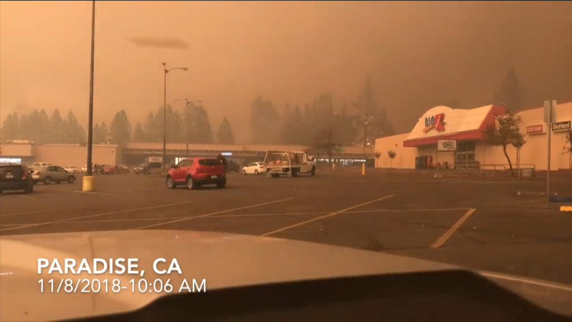
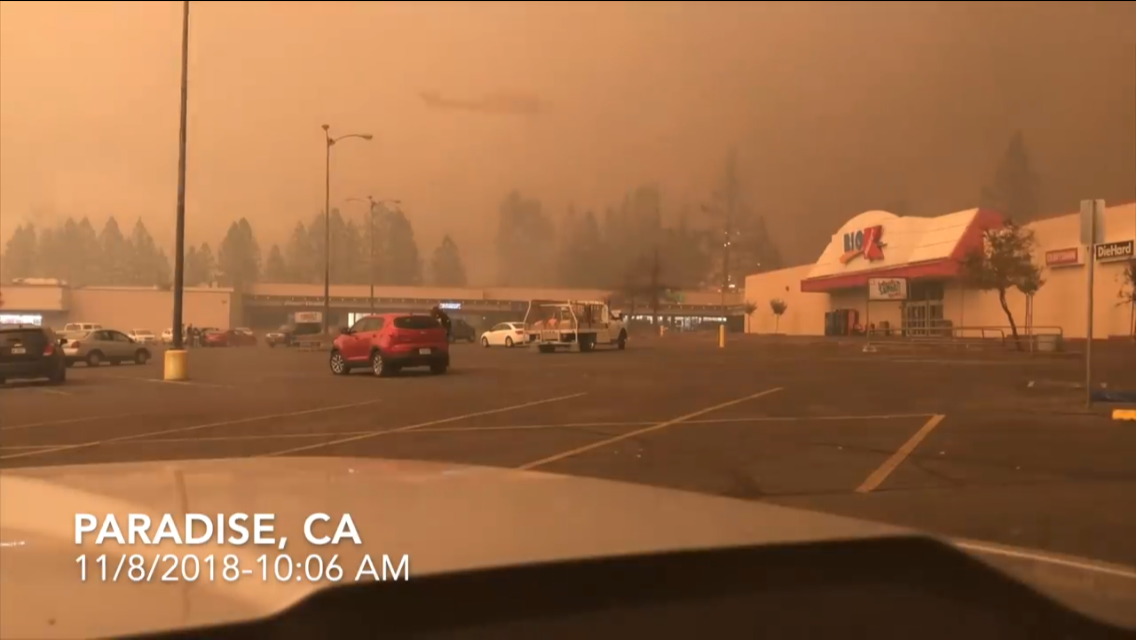
FIRE in Paradise: Images in the SMOKE
FIRE in Paradise: Images in the SMOKE
Photos about 2 hours after fires started (11/08/18)
What Do You Think These UFO’s Are?
Insider Comment:
Some of the photos look like an electronically “cloaked” helicopter, others a UFO.
Alien anti-gravity craft or US Secret Space War craft are both anti-gravity craft and have electronic capability and “biomorphic” image shape-shifting ability (as a created illusion for observers).
Conclusion is high tech – Task Force 160 “Night Stalkers” which uses high tech helicopters that are equipped with special infrared and special radar guidance systems and can fly at night and through smoke. They could have been there lighting the fires or just for observation. If they were there they would have to have been involved to make sure they didn’t get hit by the orbital to ground high powered lasers and/or particle beams.
Paradise Fire in Butte County, California
The bigger helicopter is at 13:06 and a smaller drone or something at 13:05 left side screen 3/4 up. It’s quick. And then one at 5:00 minutes in difficult to catch.
We need more eyes on these images in the video.